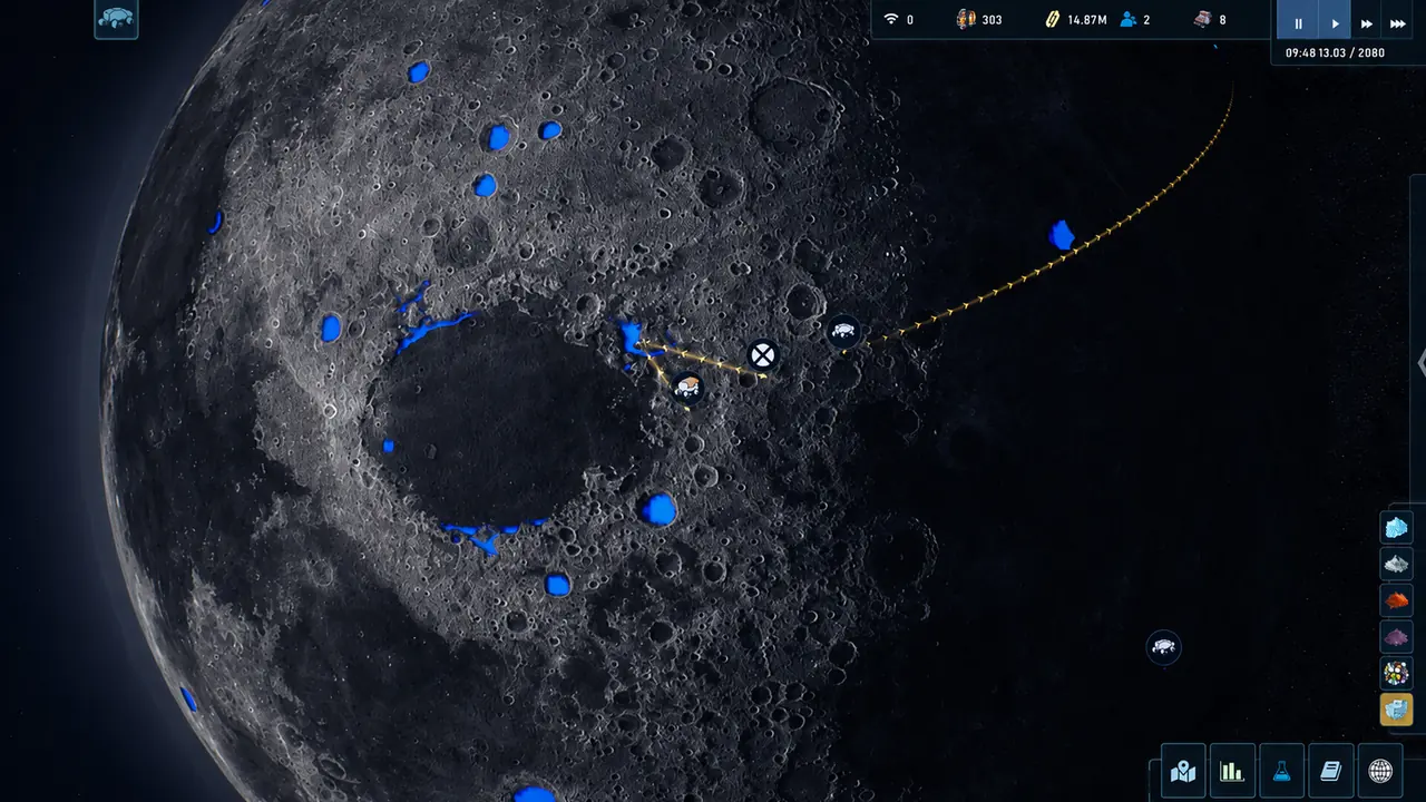
The Crust calls all of it "the map", but you are actually looking at three different maps with three different rules: the orbital view where territory, outposts and points of interest live, the surface view of your own base, and the underground layer where you excavate. Almost every map question in this game is really a question about which layer you are on. The second thing worth knowing before you spend anything: scanning is not one system. Probes, the Ore Detector and the rover's geological scanner each scan a different thing, and none of them substitutes for the others.
- Layers
- ThreeOrbital / surface / underground
- Scan tools
- ThreeProbes, detector, rover
- Starting site
- Your choiceSince Sandbox 2.0
- Anomalies
- Separate categoryNot resource deposits
- Territory
- Hold to removeChanged in Update 3
- Full scan
- Under 0.1%Rarest by far
Three maps wearing one name
Here is the distinction that resolves most map confusion, and it is worth stating plainly because the interface does not:
- The orbital map is the strategic layer. It shows the Moon, your base, outposts, points of interest, territories and the routes between them. This is where expedition sites appear as markers and where you claim ground.
- The surface map is your base itself — the build grid, roads, modules and, since Update 3, an “Improved ground map” that was one of that update’s headline items.
- The underground layer is where excavation happens, and it has its own construction interface; an official patch note records that “A level selector has been added to the underground conveyor construction interface,” which is a good sign of how separately the two views are treated.
The practical consequence: an instruction like “scan the area” is not actionable until you know which layer it refers to. Probes operate on the orbital layer. The Ore Detector and the rover’s scanner work on the surface. Nothing scans the underground for you, which is why the game instead highlights which cells are worth building on.
Reading the scan overlay
The blue coverage on the first image is the resource scan, and it is a record of where you have looked, not a prediction of what is there. That distinction matters because it changes the order you do things in: scanning is what turns the map from a picture into an inventory.
Around the map edge sits a column of resource-type filter icons — the same filter idea the game applies elsewhere. Official notes record adding “resource filters in Cargo Docks” and removing “gases from distributor filters,” so filtering by resource type is an established interface pattern here rather than a one-off map feature. Use it. A fully scanned Moon with every resource type visible at once is unreadable; a fully scanned Moon filtered to one oxide is a shopping list.
The dashed yellow line crossing the map in that screenshot is a route between settled points, and it is worth understanding what routes are for now. The 1.0 feature list introduced roads for trucks and ground transport between sites, and Update 3 explicitly framed outposts as the beginning of a logistics network: the developers described adding a smelter at outposts because it “already allows for the creation of more specialized outposts and the establishment of automated delivery routes for finished resources to the main base,” while noting they were “developing the concept (spoiler) of trade and transport logistics on the global map.” The map is a logistics diagram that you are still filling in.
Three scanning tools, three different jobs
The single most common wasted-effort mistake here is assuming one scanner does everything. It does not.
| Tool | What it scans | Where it works | Key behaviour |
|---|---|---|---|
| Anomaly Probe / Anomaly Scanner | Anomalies, resources, territories | Orbital layer | Tutorials added in Update 3; launched in a dedicated probe mode |
| Ore Detector | Ore-rich regolith veins | Surface, outdoors only | Draws battery power; larger scan area costs more energy |
| Rover geological scanner | Surface resource map | Surface, via a vehicle | Requires a research; also used to find MDR mining sites |
The probe system is the newest of the three and the one the developers were still actively polishing after launch. Update 3 added “tutorials for Anomaly Probes and the Anomaly Scanner”; Update 0.99.92 added “sound to the process of scanning anomalies, resources, and territories with probes”, which is a quiet confirmation that probes scan all three of those categories, not just anomalies; and Update 3’s cleanup pass “Removed an unnecessary text block in probe launch mode.” Probe launch is its own mode with its own zone limitation — Hotfix 0.99.90.3 records a fix to “the sound behavior in probe launch mode when moving the mouse with the zone limit,” and the “zone limit” is the part to internalise. You are painting an area to scan, not clicking a point.
The Ore Detector is a building, not a vehicle, and it is the tool people miss because it is filed under production rather than mapping.
The community wiki describes it as a "Scanner for finding ore-rich regolith veins. Uses battery power, depending on the size of the scan area. Cannot be installed indoors." Its usage note is the operationally useful part: you "select a built ore detector, wait for it to charge, and designate an area for scanning," and "the larger the scanning area, the more energy is required."
Two design details there are load-bearing. It runs on battery power rather than being a permanent draw, which means scan range is budgeted rather than free. And it cannot be installed indoors, so it competes for surface real estate — you are placing a scanning building, not a menu option.
That page carries a version tag below the current build, so treat the behaviour as reliable and any construction or power figures on it as historical.
Source: thecrust.wiki.gg community wiki, Ore Detector page, tagged version 0.99.82.8. Community tier.
The third tool is the rover, and it is the one that connects mapping to mining. The research that unlocks it is explicit about the link — it “Equips the rover with a geological scanner, allowing the creation of a resource map of the Moon’s surface. Helps determine mining sites for the Mobile Bore Unit” — and it goes on to unlock a scan-radius upgrade and the Anomaly Scanner. In other words, the rover is how the surface gets mapped, and the map is how you decide where to dig.
The rover also does things you would not expect a scout vehicle to do. An official balance note records adding an option — written in the notes as “come and scan with LPS scanner” — that appears when you assign a rover by right-click, and the same release notes separately record “Fixed an issue where geological exploration could not be performed using right-click.” Right-click assignment is the fast path for both, and for a long time it was broken.
Scanning order that avoids rework. Probe the orbital layer first, because points of interest and anomalies are strategic and cheap to find. Then build an Ore Detector once you have a candidate region, to find the ore-rich veins inside it. Then send the rover to produce the surface resource map that decides where a Mobile Drilling Rig goes. Each step narrows the search space for the next; doing them out of order means scanning the same ground twice.
Magnetic anomalies are real, and they are not in the patch notes
This is the clearest example on this site of why “we could not find it” and “it does not exist” are different claims.
We ran a full-text search of the complete official announcement and patch-note history for this game — all 147 posts — for the word “magnetic” and got zero hits. Run that search and you would reasonably conclude the term is community invention.
It is not. The developer’s own achievement metadata describes the achievement “Signal in a Bottle” as:
“Discover a magnetic anomaly”
2.7% of players have unlocked "Signal in a Bottle". It is the sixth-rarest achievement in the game and the rarest that is not tied to a late-game production milestone or a story outcome.
Anomalies live in a completely separate budget from resources. An official balance pass adjusted them as a category: "Reduced the number of science anomalies in orbital generation by 10%. Reduced the total number of anomaly points in orbital generation by 8%." That is generation-side tuning, not placement — anomalies are placed when the map is created.
Anomalies also carry effects. One official note "Balanced the anomaly that improves solar panel generation at outposts: 15% → 20%," and another records "Updated anomaly descriptions — the displayed values now correctly match gas extraction speed," noting the values had previously been wrong. If you are reading an anomaly's stated bonus, read it in a recent save.
Sources: Steam achievement descriptions and completion percentages for app 1465470, captured 17 September 2026; official Update 0.99.88 and Update 0.99.87 patch notes.
So: search the announcements and anomalies look like flavour text. Read the achievements and one of them is a distinct discoverable object with a 2.7% pickup rate. The narrower lesson generalises — the announcement history documents changes, the achievement data documents what exists. Neither one alone is a complete picture, and this page uses both.
"The Crust" — the achievement for scanning the entire surface of the Moon for resource deposits — is the rarest in the game by a very wide margin, and it is also the one place on this page where two official sources do not agree. The public achievement page displays 0.1%; the achievement API returns 0.0.
That is rounding and sampling at the extreme low end rather than a contradiction, but it is worth reporting both instead of quietly picking the friendlier number. A site that quotes a precise figure should say when its own sources disagree about one.
Sources: Steam public achievement page and the achievement-percentage API for app 1465470, both read 17 September 2026.
Points of interest are the real content of the map
The part of the orbital map that actually consumes play time is not the scan overlay. It is the markers.
The 1.0 announcement added “New barter points of interest added to the global map,” and the achievement list confirms that named sites are a tracked progression track rather than scenery: “Lost and Found” (locate the lost convoy, 33.8%), “Charlie on our six” (find the Charlie base, 31.1%) and “Heroes Never Die” (rescue all 12 survivors of Hope-2, 7.5%). A third of players have found the convoy and the Charlie base — these are mid-game content, not secrets.
The community has catalogued the named locations and their reward branches on a page tagged to build 1.0.6.1, which makes it a post-launch source rather than a stale one. It lists sites including a recyclable moon base, a demolished structure numbered RW 45-17/2075, a ruined Malachite base, an unidentified vehicle, a temporary shelter, wreckage, the Farhad Control Tower, the destroyed convoy, an unknown research outpost, an observatory and a mining site. That page also organises rewards into four difficulty bands — “walk in the park”, “challenge”, “test of strength” and “epic story” — which is useful vocabulary even if the underlying figures have moved.
We are not reproducing its resource and science-point figures, for the same reason we do not reproduce refinery tables: they are community measurements taken on one build. What is structurally reliable and worth carrying into your own game is the shape of these sites:
- Some are resolved by choosing an approach, and the branches pay differently. The unidentified vehicle offers three options — break in and find out what is inside, report the discovery to CRUST, or leave it — and only one of them returns a Control Unit.
- Some require drones sent through the Expedition Control Center rather than colonists. The destroyed convoy is one; so is the observatory.
- Some are recurring rather than one-shot. The research centre site is listed as restarting its activity, which is why it appears in a rewards table at all.
- Some unlock organisations. The Charlie-23 entry notes SCT Ltd. becoming available in the contract system — a reminder that the map is also how you meet factions.
What this page does not claim. No scan radii, no anomaly counts, no deposit volumes, no reward quantities and no coordinates. Those figures have been changed repeatedly — anomalies were re-tuned as a generation category, vein radius was "Increased" in one patch, and the whole starting-position system was replaced in Sandbox 2.0. What is documented and stable: there are three map layers, three separate scanning tools, discoverable anomalies that are distinct from resource deposits, named points of interest with branching outcomes, and a starting location you now get to choose.